

By: Dr VK Bahuguna
Indian Himalayas are spread over 13 States i.e. Jammu & Kashmir, Ladakh, Himachal Pradesh, Uttarakhand, Arunanchal Pradesh, Nagaland, Mizoram, Manipur, Meghalaya, Sikkim, Tripura, Assam and West-Bengal, covering 5, 31,250 sq km area which is around 16.6 % of the country’s geographical area. The term Himalayas derived from Sanskrit connotes Hima meaning ‘snow’ and ‘alaya’ means ‘abode’, is one of the most magnificent young mountain system in the world. It forms the Northern boundary of India. It forms a 2500 km long Arc covering Tibet, China, Afghanistan, Pakistan, Bhutan and Nepal. Himalayas help us in preventing the Monsoon winds to cross further north as also stops the dry and cold winds of Central Asia entering India. In recent years Himalayas are witnessing increasing natural disasters leading to huge loss of human life and other resources. The recent disasters in Himachal Pradesh and Uttarakhand have again posed a challenge of gigantic proportion before the planners and policy makers. The natural calamities are getting accentuated by neglecting climatic change phenomenon, lopsided urban and rural planning and geological and seismic reasons.
In order to assess the causes and to mitigate the disasters we need to understand the overall pattern of Governance and the role people of the region are playing in disturbing the basic fibre of Himalayan geology and hydrology. Himalayas are divided into three distinct vertical zones. The outer Himalayan Siwalik ranges covering from 3000 feet to 5000 feet have cultivation in flat valleys have high population density and carry huge silts during rains due to heavy deforestation. The Lesser Himalayas covering up to 15,000 feet are separated from Siwalik ranges by a fault and are full of rivers, streams with deep gorges and fed by the Glaciers which are getting affected by the rising temperatures. The Great Himalayan ranges are above the snow line and have most of the Glaciers. The food bowl of India the Indo-Gangetic plain is fed by the rivers and is prone to damages by the floods and landslides occurring in the Himalayas during the South West Monsoon thus affecting the life of millions of Indians as we witness every year in UP, Bihar and Bengal. At the point of confluence of these mountainous ranges there are changes in alignment of the geological systems giving rise to many other mountainous hill ranges. On account of the continuous shift of Indian Tectonic plate towards North-East by 5 cm every year and under thrusting the Eurasian plateau results in several earth quakes. We also know that the Himalayan mountain ranges and Tibetan Plateau were formed after the collision of Indian Plateau with Eurasian Plateau and we need to be aware and prepared upfront about the lurking and increasing disasters that we may witness in future. Due to these earth quakes landslides take place and severely disturb the geology of the area and the courses of rivers, streams and their tributaries. Our planners, policy makers, and local social workers/people as well administrators and engineers need to be reminded that in the past several thousand people have died since 1900 due to the earth quakes, landslides and flash floods.
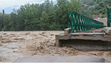
This year more than 75 people were killed in Himachal Pradesh during Monsoon with 128 roads, houses as well bridges badly damaged with almost 47 roads in Kullu-Manali and Shimla area alone. On 9th July 2023 all time high rains of 103 mm was recorded in Himachal. It is estimated that more than 12,000 crore damages (with almost Rs 4000 crore lost in three days according to ‘Down to Earth’ Magazine report) was reported which severely affected the Apple growers also and thus economically ruined thousands of farmers and businessmen. Because of climate change for past few years already Apple production is affected as snow is eluding the Apple growing elevations.
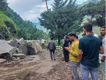
The situation in Uttarakhand is even grimmer with subsidence noticed in Joshimath and huge damages with more than 400 roads, several houses and bridges damaged by the Monsoon furry causing floods and landslides and death of many people. In Uttarakhand the Construction of all Weather Road for the ‘Char Dham’ had proved a night mare because the way it was constructed has severely disturbed the Ecology, Economy and Geology of the hills. Such roads in Himalayas need to be constructed on pillars rather than breaking the vulnerable slopes like China does in their fragile hills. Take the example of Joshimath; the reports of Scientists have now clearly indicated that the prevention of the sub-surface water streams and rivulets is the cause of subsidence of land leading to damage to hundreds of houses. The reckless expansion of Joshimath which is situated on big unsettled debris without any solid rocks below, the disaster was waiting to happen and a report long back by one senior officer who had warned the authorities but it was ignored. I had while leading a Central Government inter-ministerial team in 1999 after the flash floods in Rudraprayag District have pin pointed two major reasons for the disasters. First, choking off the drainages all along the hills and; Second the unplanned construction of houses, roads and buildings by locals as well as the government agencies on geologically unstable and ecologically vulnerable slopes. Due to these small lakes, streams are formed inside the soil which while finding their way in sub-surface soil during heavy rains, creates havoc with flash floods and landslides. Our team had suggested preparation of geological maps right from block levels with complete resources inventory. In 2011 the National Rainfed Area Authority had sanctioned 6 crore to FRI Dehradun for preparing such maps for 275 Districts including Himalayas and the reports are ready. The resource inventory should be used to prepare development strategy for each town and blocks and shift the villages situated on vulnerable slopes. The other very important recommendation was to ensure that no drainages are choked and manage the sub-surface hydrology which is implemented rather fully in breach. Incidentally, after 14 years of our recommendations, many of the villages identified by us were washed down in June 2013 Kedarnath tragedy.
The case in point for better management of drainage is Nainital. In 1880 or so several hundred people died due to landslides and there after the British made it a point that the drainages system of Nainital is foolproof and for more than 100 years Nainital is stable though now the people should not disturb it as construction and development had already reached its carrying capacity.
I would like to recommend that Prime Minister who is a keen lover of Himalayas to redefine the development paradigm of Himalayas and ensure a completely new strategic vision based on scientific parameters including translocation of population if needed and plan a process to make Himalayan mountain range a climate resilient stable hills where the people and nature can co-exists. Being situated in international border the army will have to play a key role in changed scenario. The complacency will surely invite many more disasters as people often have forgotten to learn from their mistakes.
(The writer is former Director General Indian Council of Forestry Research and Education & Chancellor FRI Deemed University)
